A viral video showing a man walking on power lines to escape floods—falsely claimed to have been filmed in Bangkok in 2026—is actually footage of the 2025 floods in Hat Yai.
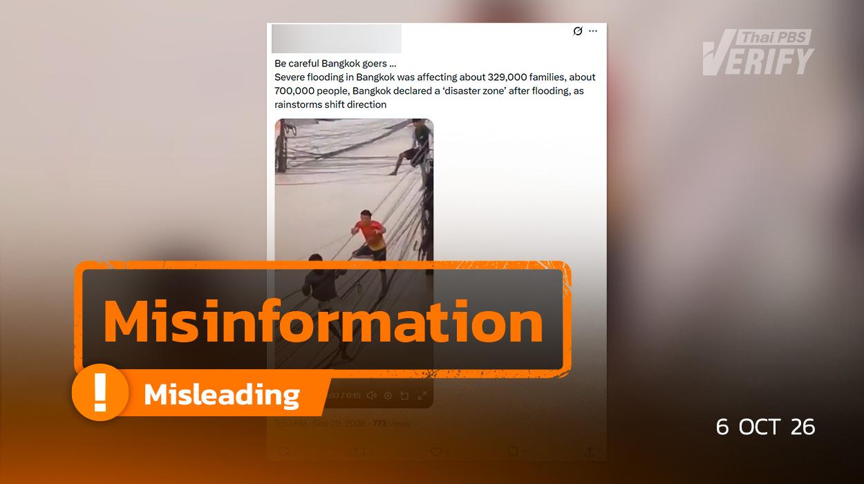
Thai PBS Verify traced the source of the misinformation back to X.
Thai PBS Verify identified an account on X that shared a photo showing an individual walking along utility lines during a flood, accompanied by the claim: “Be careful Bangkok goers …Severe flooding in Bangkok was affecting about 329,000 families, about 700,000 people, Bangkok declared a ‘disaster zone’ after flooding, as rainstorms shift direction”
Travelers heading to Bangkok are advised to exercise caution… Bangkok is facing severe flooding, affecting approximately 329,000 households or about 700,000 people. Bangkok has been declared a ‘disaster zone’ following the floods, as rainstorms are shifting direction,” posted on September 29, 2026.
Is the video/image of a person walking on power lines during the floods real or fake?
Thai PBS Verify investigated the image using AI image-checking tools like The Hive.
And Decopy showed no evidence of the image being AI-generated.
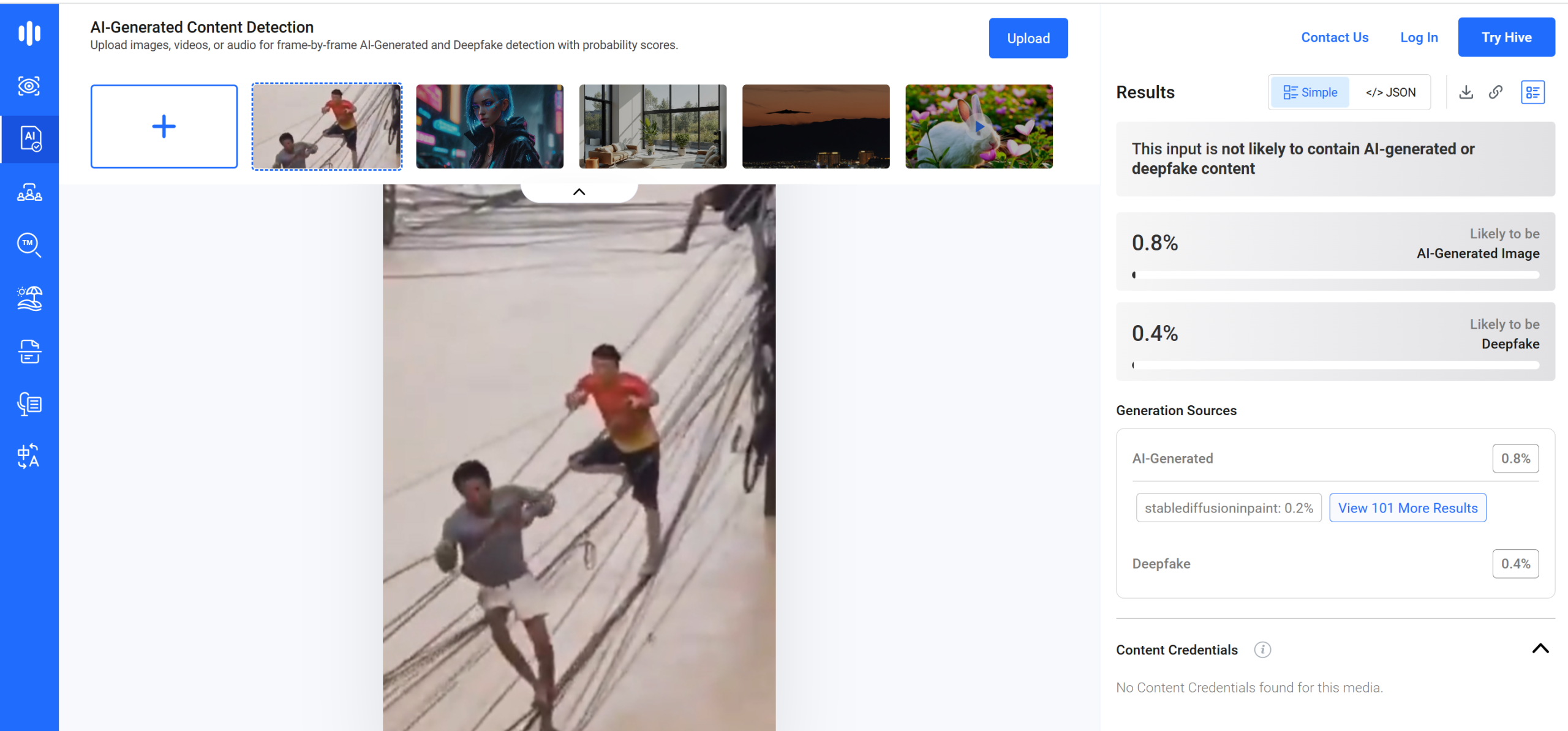
Results from the verification analysis on The Hive

Results from the verification analysis on Decopy
An image search via Google Lens by Thai PBS Verify revealed the photo was published by the Bangkok Post in an article titled ‘Rising water forces hospital airlift’ on November 26, 2025.
The details are as follows:
Clips depicting flood conditions in Hat Yai have been circulating online. Among them is a video posted by Facebook user Kang Namthip on November 25, 2025, showing three men climbing across power lines over raging floodwaters to survive amid continuous rainfall.
The poster included a plea for help, stating: ‘Please have mercy on us. Many other lives are still waiting in hope of being rescued. The water has reached the second floor, and our food and water are running low. Please help us. We cannot contact any rescue units.’ The post also provided specific locations—Phon Phichai Road, Wat Phutthikaram, in front of Wat Plak Kriam Nai—along with a contact number for assistance.
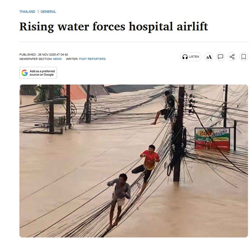
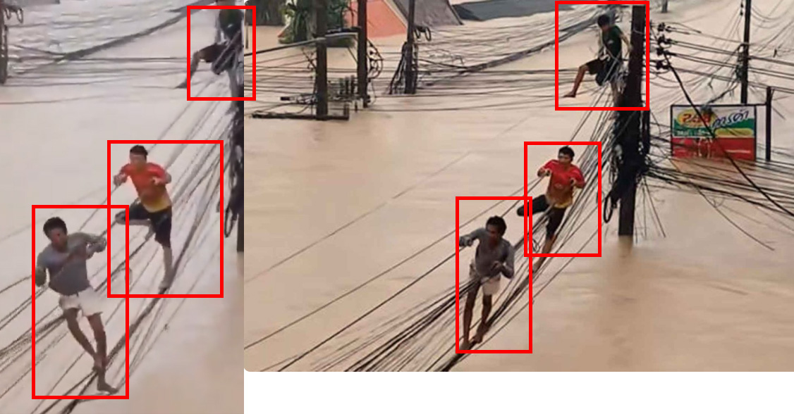
Comparison image: The post (left) and the image from the Bangkok Post website (right)
ต่อมา เมื่อนำภาพดังกล่าวไปเทียบกับ Google Maps พบเป็นพื้นที่บริเวณหน้าวัดพุทธิการาม (ปลักกริมใน) ตั้งอยู่ใน อำเภอหาดใหญ่ จังหวัดสงขลา
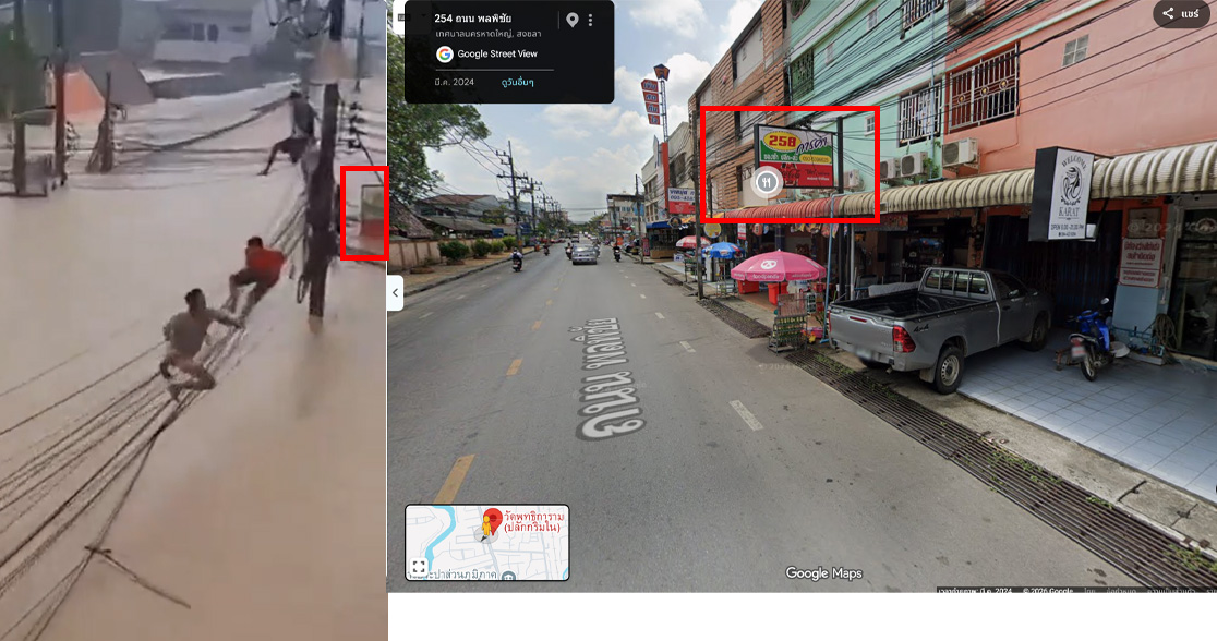
ภาพเปรียบเทียบจากโพสต์(ซ้าย) และภาพจาก Google Maps (ขวา)
สถานที่ใน Google Maps
ตัวเลขจำนวน ประชาชนราว 329,000 ครัวเรือน หรือประมาณ 700,000 คน มาจากไหน ?
Thai PBS Verify ใช้การค้นหาคำสำคัญ “ประชาชนราว 329,000 ครัวเรือน หรือประมาณ 700,000 คน ” พบว่า เมื่อวันที่ 28 ก.ย. 69 นางสาวทวิดา กมลเวชช รองผู้ว่าราชการกรุงเทพมหานคร เปิดเผยว่า ข้อมูลจากศูนย์บัญชาการฯ ระบุว่า ตั้งแต่เริ่มเกิดสถานการณ์น้ำท่วม มีประชาชนได้รับผลกระทบทั้งในระดับน้อยและมากประมาณ 329,000 ครัวเรือน หรือราว 700,000 คน
พื้นที่ที่มีน้ำท่วมลึกและมีประชาชนได้รับผลกระทบจำนวนมาก ได้แก่ เขตลาดกระบังประมาณ 30,000–40,000 คน เขตบางกะปิประมาณ 20,000 คน และเขตคันนายาวประมาณ 30,000–40,000 คน
ขณะที่เขตสะพานสูง สวนหลวง และหลักสี่ ยังมีประชาชนในพื้นที่น้ำท่วมและชุมชนริมคลองได้รับผลกระทบ โดยเขตหลักสี่มีประมาณ 10,000 คน
นางสาวทวิดาระบุว่า ภารกิจสำคัญในขณะนี้ นอกจากการเร่งระบายน้ำ คือการดูแลประชาชนที่ยังอยู่ในพื้นที่น้ำท่วม โดยเฉพาะผู้สูงอายุ ผู้ป่วยติดเตียง รวมถึงประชาชนที่ขาดแคลนอาหารและน้ำดื่ม หรือไม่สามารถเดินทางออกจากพื้นที่ได้

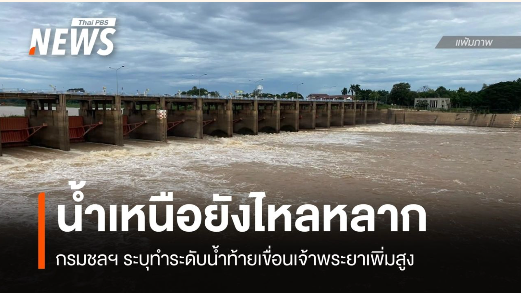
กรมชลประทานแจง น้ำป่าสักเพิ่ม เตือนพื้นที่ริมแม่น้ำป่าสัก ยืนยันยังไม่กระทบกรุงเทพฯ
เมื่อวันที่ 5 ต.ค. 69 กรมชลประทานอัปเดตสถานการณ์ลุ่มน้ำเจ้าพระยาและลุ่มน้ำป่าสัก โดยระบุว่า เวลาประมาณ 06.30 น. กรมชลประทานรายงานสถานการณ์ลุ่มน้ำเจ้าพระยา โดยที่สถานี C.2 อ.เมือง จ.นครสวรรค์ มีปริมาณน้ำไหลผ่าน 2,038 ลูกบาศก์เมตรต่อวินาที (ลบ.ม./วินาที) มีแนวโน้มลดลง ขณะที่สถานี C.13 เขื่อนเจ้าพระยา จ.ชัยนาท มีปริมาณน้ำไหลผ่าน 2,500 ลบ.ม./วินาที ระดับน้ำเหนือเขื่อนอยู่ที่ +17.32 เมตร เมื่อเทียบกับระดับน้ำทะเลปานกลาง และทรงตัว
กรมชลประทานระบุว่า แม้น้ำตอนบนบางจุดเริ่มลดลง แต่ปริมาณน้ำที่ไหลเข้าสู่เขื่อนยังอยู่ในระดับสูง และมีน้ำสะสมเหนือเขื่อน จึงจำเป็นต้องทยอยปรับเพิ่มการระบายน้ำเป็นขั้นตอน เพื่อควบคุมระดับน้ำและลดความเสี่ยงต่อพื้นที่เหนือเขื่อน รวมถึงลดผลกระทบจากการเพิ่มขึ้นของระดับน้ำในพื้นที่ท้ายเขื่อน
หากระดับน้ำทางตอนบนเพิ่มสูงขึ้น และส่งผลให้ปริมาณน้ำไหลผ่านเขื่อนเจ้าพระยาเพิ่มขึ้น กรมชลประทานจะแจ้งสถานการณ์ให้ประชาชนทราบอีกครั้ง
สำหรับ สถานการณ์ลุ่มน้ำป่าสัก พบว่า เขื่อนป่าสักชลสิทธิ์ จ.ลพบุรี มีปริมาณน้ำเก็บกัก 957 ล้านลูกบาศก์เมตร คิดเป็น 110% ของความจุ ระบายน้ำอยู่ที่ 500 ลบ.ม./วินาที และมีแนวโน้มเพิ่มขึ้น ขณะที่เขื่อนพระราม 6 จ.พระนครศรีอยุธยา มีปริมาณน้ำไหลผ่าน 675 ลบ.ม./วินาที มีแนวโน้มเพิ่มขึ้นเช่นกัน
กรมชลประทานคาดว่า ระดับน้ำในแม่น้ำป่าสักบริเวณท้ายเขื่อนพระราม 6 จะเพิ่มขึ้นจากระดับปัจจุบันประมาณ 1.00–1.20 เมตร โดยพื้นที่ที่ต้องเฝ้าระวังเป็นพิเศษ ได้แก่ พื้นที่ริมแม่น้ำป่าสักใน อ.ท่าเรือ จ.พระนครศรีอยุธยา ได้แก่ ต.ท่าเรือ ท่าหลวง จำปา ท่าเจ้าสนุก ศาลาลอย วังแดง โพธิ์เอน และปากท่า
สำหรับแม่น้ำป่าสักจะไหลมาบรรจบกับแม่น้ำเจ้าพระยา ก่อนผ่านสถานี C29B อ.สามโคก จ.ปทุมธานี ซึ่งเป็นจุดวัดปริมาณน้ำเจ้าพระยาก่อนเข้าสู่พื้นที่กรุงเทพฯ โดยมีปริมาณน้ำไหลผ่านเฉลี่ย 2,532 ลบ.ม./วินาที และกำหนดควบคุมไม่ให้เกิน 3,600 ลบ.ม./วินาที
กรมชลประทานยืนยันว่า สถานการณ์ดังกล่าวยังไม่ส่งผลกระทบต่อพื้นที่กรุงเทพฯ พร้อมระบุว่า หากระดับน้ำทางตอนบนเพิ่มสูงขึ้นและส่งผลให้ปริมาณน้ำไหลเข้าเขื่อนป่าสักชลสิทธิ์เพิ่มขึ้น จะรายงานสถานการณ์ให้ประชาชนทราบเป็นระยะ
เรื่องจริงเป็นอย่างไร ?
Thai PBS Verify ตรวจสอบพบว่า ภาพคนเดินบนสายไฟขณะน้ำท่วมเป็นภาพเหตุการณ์จริง แต่ไม่ใช่ภาพสถานการณ์น้ำท่วมกรุงเทพฯ ในปี 2569 โดย Google Lens พบว่าภาพดังกล่าวปรากฏในข่าว “Rising water forces hospital airlift” ของเว็บไซต์ Bangkok Post ซึ่งเผยแพร่เมื่อวันที่ 26 พ.ย. 2568
ส่วนข้อความที่ระบุว่า กรุงเทพฯ มีประชาชนได้รับผลกระทบจากน้ำท่วมประมาณ 329,000 ครัวเรือน หรือราว 700,000 คน มีที่มาจากข้อมูลจริง โดยเมื่อวันที่ 28 ก.ย. 2569 นางสาวทวิดา กมลเวชช รองผู้ว่าราชการกรุงเทพมหานคร ระบุว่า ตั้งแต่เริ่มเกิดสถานการณ์น้ำท่วม มีประชาชนได้รับผลกระทบทั้งในระดับน้อยและมากประมาณ 329,000 ครัวเรือน หรือราว 700,000 คน โดยพื้นที่ที่มีน้ำท่วมลึกและมีประชาชนได้รับผลกระทบจำนวนมาก ได้แก่ เขตลาดกระบัง บางกะปิ และคันนายาว
อย่างไรก็ตาม ตัวเลขดังกล่าวเป็น จำนวนประชาชนที่ได้รับผลกระทบจากสถานการณ์น้ำท่วมในกรุงเทพฯ ตั้งแต่เริ่มเกิดเหตุ ไม่ได้หมายความว่าประชาชนทั้งหมดกำลังเผชิญน้ำท่วมรุนแรงในช่วงเวลาที่โพสต์ดังกล่าวถูกเผยแพร่
สำหรับสถานการณ์น้ำในวันที่ 5 ต.ค. 2569 กรมชลประทานรายงานว่า แม้ลุ่มน้ำป่าสักมีปริมาณน้ำเพิ่มขึ้น โดยเขื่อนป่าสักชลสิทธิ์มีน้ำเก็บกัก 957 ล้านลูกบาศก์เมตร หรือ 110% ของความจุ และมีการระบายน้ำ 500 ลูกบาศก์เมตรต่อวินาที แต่กรมชลประทานระบุว่า สถานการณ์ดังกล่าวยังไม่ส่งผลกระทบต่อพื้นที่กรุงเทพฯ พร้อมเฝ้าระวังระดับน้ำในพื้นที่ริมแม่น้ำป่าสักและติดตามสถานการณ์น้ำอย่างต่อเนื่อง
ดังนั้น โพสต์ดังกล่าว นำภาพเหตุการณ์น้ำท่วมที่เกิดขึ้นจริงในปี 2568 มาใช้ประกอบข้อมูลสถานการณ์น้ำท่วมกรุงเทพฯ ในปี 2569 ขณะที่ตัวเลขประชาชนได้รับผลกระทบ 329,000 ครัวเรือน หรือราว 700,000 คน มีที่มาจากข้อมูลของ กทม. จริง แต่การนำภาพเก่ามาประกอบข้อความอาจทำให้เข้าใจว่า ภาพดังกล่าวเป็นเหตุการณ์น้ำท่วมกรุงเทพฯ ในช่วงเวลาที่โพสต์เผยแพร่ ซึ่งไม่ถูกต้อง
Verification Process
- AI Detection Check: The image within the clip was analyzed using AI-checking tools including The Hive and Decopy. The results confirmed that the image was not artificially generated by AI.
- Google Lens Analysis: Upon running the image through Google Lens, investigators found that the photo was originally featured in a Bangkok Post report titled ‘Rising water forces hospital airlift’, published on November 26, 2025.
- Google Maps Verification: Comparing the image with Google Maps revealed that the location corresponds to the area in front of Wat Phutthikaram (Plak Kriam Nai), located in Hat Yai District, Songkhla Province.
- Keyword Analysis: By conducting a keyword search for ‘329,000 households or roughly 700,000 people’, investigators discovered that on September 28, 2026, Bangkok Deputy Governor Tavida Kamolvej revealed information from the flood command center. The data showed that an estimated 329,000 households, or roughly 700,000 individuals, have experienced varying levels of impact from the floods.
The Impact of This Misinformation
- Misleads people into thinking the power-line photo is from the 2026 Bangkok floods instead of 2025.
- Causes public miscalculation of flood severity, triggering undue panic.
- Disrupts travel planning for commuters and residents in Bangkok.
- Using the 329,000 household (700,000 people) figure out of context implies widespread, simultaneous severe flooding.
- Blurs past events with current news, undermining trust in official disaster alerts.
What to do with this misinformation?
- Check images and dates before sharing, as flood photos are often outdated.
- Verify numbers with official agencies like the BMA or water authorities to understand the correct context.
- Do not share posts right away if the text and images cannot be verified as matching events.
- Stop spreading posts that mix old photos with current data misleadingly, and share verified corrections instead.
- Rely on direct announcements from relevant authorities for accurate flood and travel updates.