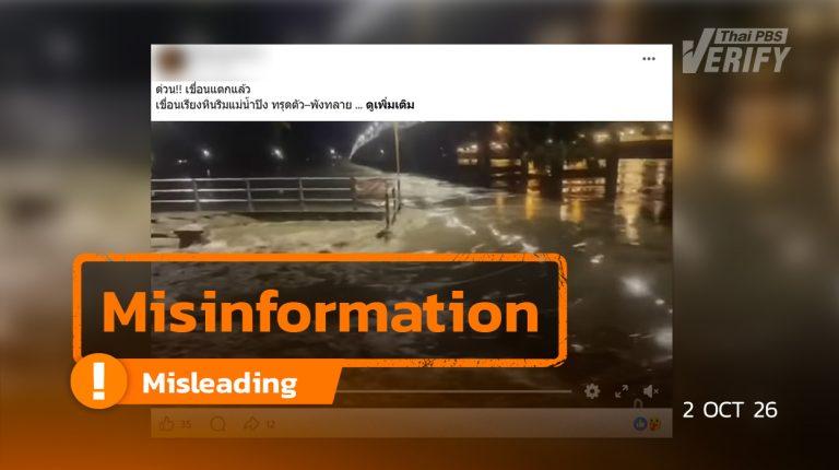
Ping Riverbank Protection Structure Damaged, Not a Dam Collapse
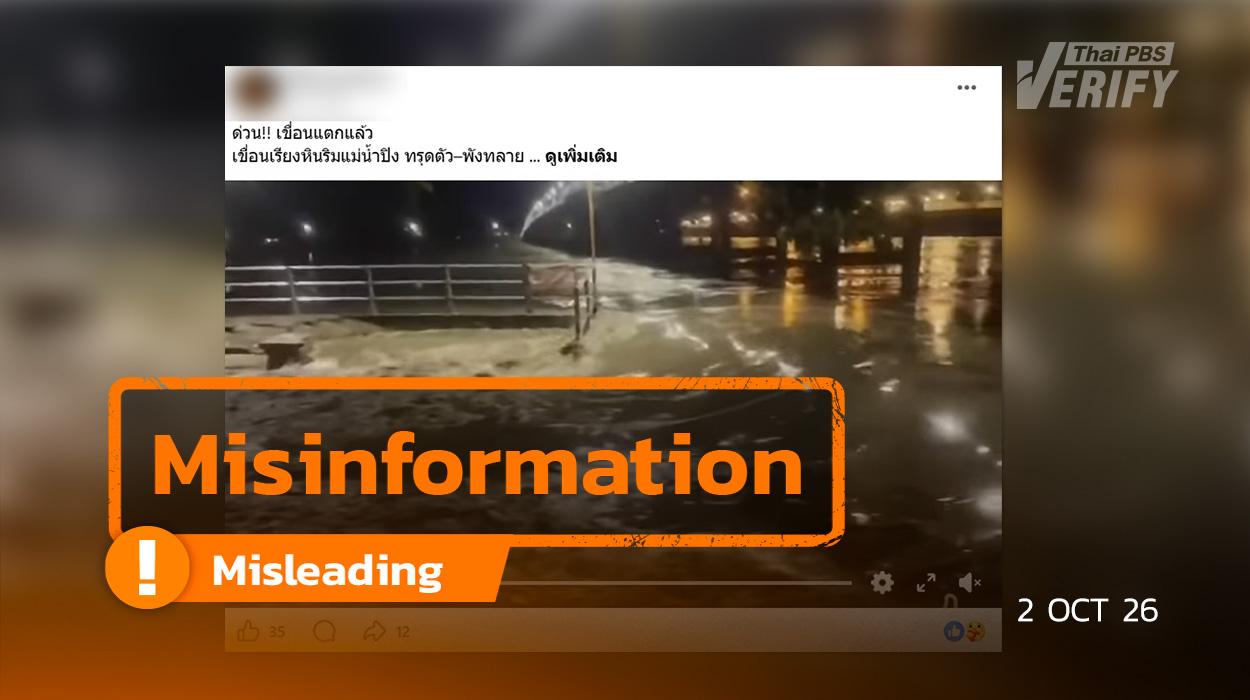
Source of the Misleading News on Facebook
Thai PBS Verify found a Facebook account sharing a video clip showing flooding accompanied by the caption: “URGENT!! Dam collapsed! Stone riprap dam along the Ping River slumped and collapsed. Residents along the Ping River must stay vigilant and move belongings to higher ground. Photo/News Credit: This is Kamphaeng Phet.” This content was posted on September 30, 2026.
Thai PBS Verify submitted images from the post to AI detection tools, including Hive Moderation and ZeroGPT, and found no evidence that the images were AI-generated.

Verification results from the Hive Moderation website
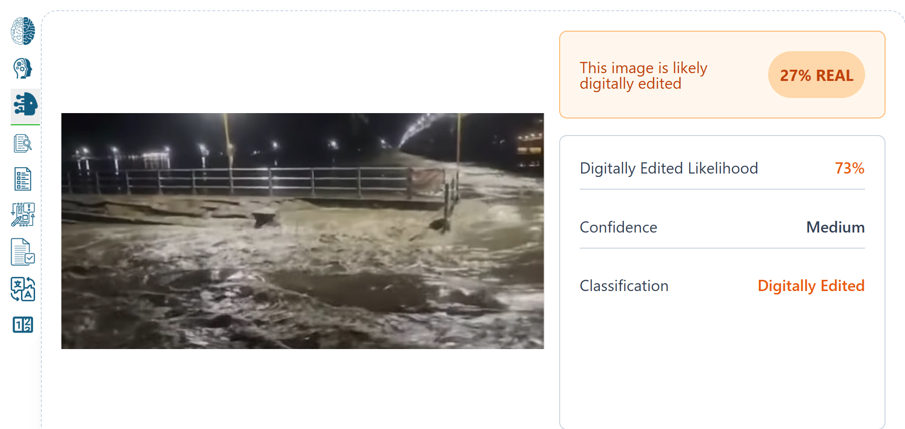
Verification results from the ZeroGPT website
A keyword search for “stone riprap dam” led to an Amarin News report titled “Urgent! Kamphaeng Phet Rushes to Repair a Stone Riprap Structure After 12-Meter Section Subsides Due to Water Erosion,” published on September 3, 2026. Comparing the news image with Google Maps imagery revealed that the location was a damaged riverbank protection structure, not a collapsed dam.
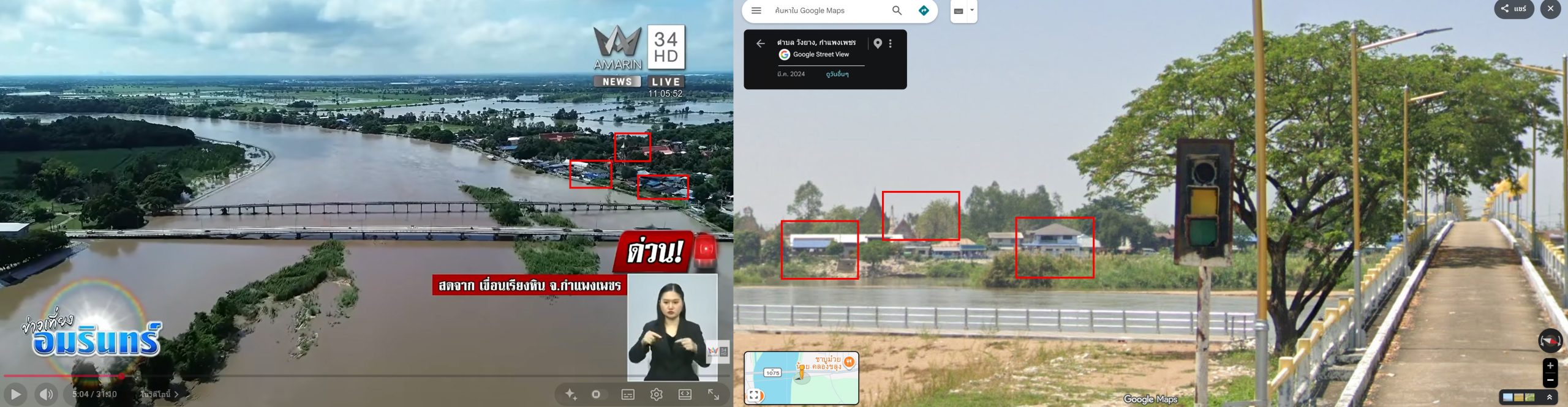
Comparison of Amarin News (left) and Google Maps
Did the Stone Riprap Dam Along the Ping River Really Collapse?
Thai PBS Verify performed keyword searches for “stone riprap dam along Ping River collapsed” and found that on September 30, 2026, the official Facebook page of the Khlong Khlung District Office, Kamphaeng Phet, posted an official clarification detailing the following facts:
- The Khlong Khlung District Office, Kamphaeng Phet Province, clarified regarding online social media reports alleging a “dam collapse” in the Tha Ma Khuea area, which could lead the public to mistakenly believe that a major water storage dam or river barrier had burst.
- The district office specified that the affected site is a Ping Riverbank erosion protection structure, not a water storage dam or river dam barrier. The incident involved structural damage to a section of the riverbank revetment and currently poses no threat or impact to the area.
- Simultaneously, the Khlong Khlung District Office coordinated with relevant agencies to inspect the site, initiate repairs, and closely monitor water levels and the overall situation to prevent any potential impacts on local residents and businesses.
- The district office urged the public to rely primarily on official announcements from government agencies and local authorities, and to refrain from sharing unverified information to avoid misunderstandings and panic.
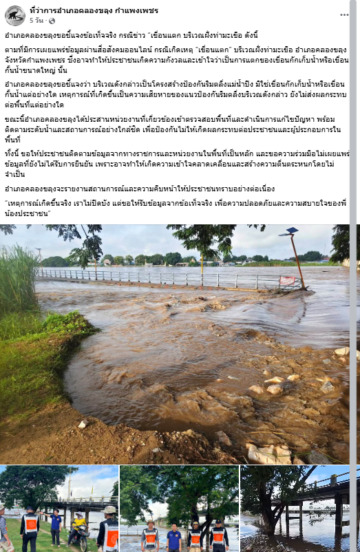
Dam image from the Khlong Khlung District Office Facebook page, Kamphaeng Phet
Regional Irrigation Office 4 Inspects Water Obstruction Clearance to Boost Drainage Efficiency in Kamphaeng Phet
A search on the Facebook page of Regional Irrigation Office 4 (RIO 4) revealed that on September 30, 2026, at 10:00 AM, Mr. Piya Lue-utikulwong, Director of Regional Irrigation Office 4, tasked Mr. Singha Sriboonma, Director of the Machinery Division, along with officers and related agencies, to inspect machinery operations removing weeds and water obstructions at Khlong Khayaeng, Khlong Khlung District, Kamphaeng Phet Province.
This operation aimed to clear weeds and obstacles impeding water flow, thereby enhancing local drainage capacity and preparing infrastructure for heavy rainfall during the rainy season to mitigate potential impacts on local communities.
Additionally, Regional Irrigation Office 4 instructed staff to continuously clear water obstructions and maintain tight surveillance over the water situation to ensure optimal water management efficiency and maximum benefit to the public.

What is the Current Water Situation in Northern Thailand?
On October 2, 2026, Mr. Paitoon Kengkarnchang, Deputy Secretary-General of the Office of the National Water Resources (ONWR), disclosed that water volume in northern Thailand had decreased significantly, particularly in the Ping and Sakae Krang River basins, where flow rates dropped by more than 500 cubic meters per second. Meanwhile, discharge above the Chao Phraya Dam was maintained at 2,500 cubic meters per second and can be sustained at this level for another 5–6 days to prepare for anticipated rainfall during October 11–13.
Regarding major reservoirs in the Chao Phraya River Basin:
- Bhumibol Dam is at 70% capacity.
- Sirikit Dam is at 80% capacity.
- Kwae Noi Bamrung Dan Dam is at 70–80% capacity.
- Pasak Jolasid Dam exceeds its capacity but still has downstream storage retention capacity for approximately 6 billion cubic meters, with a current discharge rate of 400 cubic meters per second.
Mr. Paitoon stated that water discharged from Pasak Jolasid Dam merges with the Chainat–Pasak Canal before entering the Chao Phraya River, flowing toward Bang Pa-in and Bang Sai districts in Phra Nakhon Si Ayutthaya Province, before proceeding to Pathum Thani and Nonthaburi. The flow volume is estimated at around 2,100 cubic meters per second. However, areas outside flood levees in Phra Nakhon Si Ayutthaya, particularly in Sena and Phak Hai districts, may experience impacts from the discharge.
For the Bangkok Metropolitan Region (BMR), water levels in the Chao Phraya River remain below riverbanks—approximately 1.2 meters below the bank in Nonthaburi, 0.57 meters in Pathum Thani, and 1.2 meters in Bangkok—allowing the system to accommodate current discharge levels. Nevertheless, close monitoring is required for rainfall during October 11–13, as localized waterlogging may occur in parts of Bangkok and surrounding provinces.
In the Tha Chin River Basin, water volume remains relatively high. Discharge is being controlled at the Pho Phraya Regulator in Suphan Buri Province to prevent downstream flooding, while water management continues actively along the Suphan Buri–Nakhon Pathom border.
Regarding Bangkok’s drainage system, water can be pumped through drainage tunnels and canals. In contrast, eastern areas such as Chachoengsao and Samut Prakan face limited drainage capacity; hence, orders have been issued to deploy additional water pumps and expedite drainage toward feasible discharge points.
In the Bang Pakong River Basin, water levels reached a new peak of 4.98 meters on October 2, approximately 11 centimeters higher than in 2013. The Royal Irrigation Department (RID) will continuously manage discharge from Khun Dan Prakarn Chon Dam to preserve storage capacity, while regulating discharge during October 11–13 to protect downstream areas.
In Eastern Thailand, minor flooding was reported in parts of Rayong and Chanthaburi provinces, with heavy rainfall expected in Chanthaburi and Trat around October 11, prompting advance emergency preparations.
In the Mae Klong River Basin, Vajiralongkorn Dam retains storage capacity for about 120 million cubic meters, while Srinagarind Dam has remaining capacity for roughly 700 million cubic meters. Discharge from Mae Klong Dam is trending downward and is expected to fall below 1,000 cubic meters per second within one week.
In the Phetchaburi River Basin, Kaeng Krachan Dam manages water levels effectively, recording inflows of 11–13 million cubic meters and outflows of around 10 million cubic meters. Monitoring remains active for expected rainfall on October 6 and October 11–13.
Mr. Paitoon reaffirmed that northern floodwaters are declining and the situation across Bangkok, Pathum Thani, Nonthaburi, and Samut Prakan remains manageable, though localized surface flooding remains possible. Residents are advised to stay updated on water levels and weather forecasts.
What is the Actual Truth?
Thai PBS Verify confirmed that physical damage occurred to a Ping Riverbank erosion protection structure in the Tha Ma Khuea area of Khlong Khlung District, Kamphaeng Phet Province. However, this was not a “water storage dam or river barrier collapse” as claimed on social media. Khlong Khlung District authorities stated they are coordinating with relevant agencies to inspect and repair the structure while closely monitoring the site, adding that no immediate impact on the surrounding area has been reported.
Overall, water volumes across northern Thailand are trending downward, particularly along the Ping and Sakae Krang river basins. Water management agencies continue regulating dam discharges to prepare for predicted rainfall during October 11–13, 2026. Water levels in Bangkok and surrounding provinces remain manageable, though localized surface water retention remains possible, requiring continued surveillance of rainfall and river levels.
Verification Process
- AI Image Verification: When images from the Facebook post were analyzed using AI detection tools such as Hive Moderation and ZeroGPT, no evidence was found that the images were AI-generated.
- Keyword Search Verification: A keyword search found an Amarin News report published on Sep 3, 2026, about a 12-meter section of a stone riprap structure damaged by erosion in Kamphaeng Phet. Google Maps comparison confirmed it was a riverbank protection structure, not a collapsed dam.
- Keyword Search Verification: Thai PBS Verify searched using the keywords “stone riprap dam along Ping River collapsed” and found an official statement posted on September 30, 2026, by the Khlong Khlung District Office Facebook page. The statement clarified that the incident in Tha Ma Khuea was damage to a riverbank erosion protection structure, not a collapsed dam or reservoir barrier, with no current impact on the local area.
- Source Verification (Irrigation Office): A search on Regional Irrigation Office 4’s Facebook page showed that RIO 4 deployed teams to Khlong Khlung District, Kamphaeng Phet, to monitor weed removal and water obstruction clearance in Khlong Khayaeng to improve drainage capacity ahead of the monsoon season.
- Source Verification (ONWR): Statements from the ONWR confirmed that northern runoff volume is declining (notably in the Ping and Sakae Krang rivers) and that water levels in Bangkok and vicinity remain manageable, though vigilance is required for rainfall during October 11–13, 2026.
Impacts of the Misinformation
- Causes Public Panic: Leads local residents to wrongly believe a major water reservoir or dam barrier has burst, despite local authorities confirming it was only damage to a riverbank revetment.
- Distorts Severity Assessment: Causes citizens to miscalculate the severity of the flood situation, leading to improper preparedness or unnecessary evacuation decisions based on inaccurate data.
- Erodes Public Trust: Undermines confidence in official water management and government updates, especially when sensational terms like “dam collapse” are used to describe minor bank erosion.
- Amplifies Misunderstandings: Facilitates repeated sharing of unverified claims, creating widespread confusion at a time when citizens are closely monitoring rainfall and flood risks.
- Overshadows Real Situation Updates: Obscures vital real-time updates that citizens should follow, such as actual river levels, riverbank erosion alerts, and local administrative warnings.
- Affects Local Residents and Businesses: Unnecessary anxiety and mismatched emergency preparations caused by misleading reports harm local businesses and communities. As Khlong Khlung District stressed, the public should rely strictly on official government sources.
What to do with this misinformation?
- Verify Specific Location and Structure Type: Pay attention to terms like “dam collapse”—in many cases, this refers to a riverbank erosion protection wall rather than a water storage dam.
- Check Time, Date, and Location: Verify the incident’s timestamp and exact location from reliable sources to prevent recycled images or clips from older events being re-shared.
- Follow Official Regional Agencies: Rely on announcements from local administrative bodies, provincial authorities, the Department of Disaster Prevention and Mitigation (DDPM), and water management agencies before drawing conclusions.
- Cross-Check Multiple Sources: If a post claims a severe disaster, verify whether official warnings or confirmations have been issued by relevant authorities.
- Do Not Share Unverified Content: Avoid forwarding unconfirmed information. If misinformation is spotted, share corrected facts along with credible references to inform others.